Friday, 7 November 2014

Blayney to Galston - a chilly postscript

15th October 2014

Last night was the coldest we had experienced on the entire trip!  In the morning we discovered there had been a widespread snowstorm and the western highway was closed between Lithgow and Mt Victoria due to the icy conditions.  There was snow from just east of Bathurst through to Blackheath.  This was an unexpected end to the holiday and an unprecedented occurrence for October!

Lithgow in the snow

We left Blayney around 9:30 in the hope the road would be open by the time we got there, which it was.  In Lithgow we parked the van and got out to enjoy the unseasonal weather.

Arrived home safe and sound late afternoon, all well with the house. The caravan will go into mothballs until next year, but in the meantime we will be making some improvements to the battery and water tank capacity to allow us to do more camping off the beaten track next time.

Monday, 13 October 2014

Hay to Blayney

14th October 2014

What  a miserable day!  Huge drive, all of it in rain and the temperature never got above 10 degrees all day.  I think this is the coldest day we have had the entire trip!  Sad end to the journey really.

We will be home tomorrow calling in at Leura on the way to assess the work to be done to our tenanted property there in preparation for sale.  We will be towing the van back up to the Blue Mountains next week so we can live in it whilst working on the Leura house.

That's it until the next trip!

Sunday, 12 October 2014

Renmark SA to Hay NSW

13th October 2014

Sad to leave Renmark this morning as we had such a lovely spot right on the riverbank.

An uneventful journey today except for the high winds. All of the journey through Victoria and then into NSW was on flat treeless plains so the wind really gets up some speed.  Poor John was grappling with the steering wheel most of the time.

Hay was founded in the early 19th century as it was an excellent position for people travelling north, and south to the Victorian goldfields.  The town is on the Murrumbidgee River so water was never a problem.  Later the river was used for trade down to the confluence with the Murray but now the town just services the local livestock farming community and passing travellers like us. Unfortunately Hay is another country town that seems to be slowly dying.  The caravan park is very good though.

Around Renmark and Paringa

12th October 2014

Another lovely day and this time we got out the bikes and followed the foreshore trail from the caravan park along the river for several kilometres.  Renmark is a really nice town and was the first settlement on the Murray to have an irrigation scheme.

Water intake for the Renmark irrigation scheme
After lunch we cycled south of the town to a lovely rose garden which also houses a restaurant and a small classic car collection.  So there was something for everyone there.  Renmark seems to be a bit crazy for roses - there is a rose festival starting here in a few days and lots of the private homes have lovely rose gardens as do many of the public parks.

Beautiful velvety rose at Ruston Roses


Later we drove upstream to a lookout in Paringa where the river bank is about 30 metres high. Renmark is very flat but the last big floods were in 1956 as the river is controlled by locks.

Headings Cliffs, Paringa


Saturday, 11 October 2014

Wilpena to Renmark via Peterborough and Burra

11th October 2014

We really are on our way home now, just inside the SA border tonight.

Tin sculptures on the way to Burra
The journey was uneventful but we pulled up outside a 'tin sculpture garden for morning tea. Just a little nondescript settlement on our journey where someone with a quirky outlook lives.

Always great to be able to stop any old place and put the kettle on.


Lovely view of the Murray from our camp spot
We are camped in a huge caravan park in Renmark,  Actually the facilities are very good. We have a lovely spot right on the Murray River and were able to enjoy a beautiful sunset right from our door! Doesn't get better than that.
Sunset over the Murray, SA


Thursday, 9 October 2014

Bunyeroo Gorge, Flinders Range

10th October 2014

Another hot day so we planned to be at our gorge walk nice and early as it was a 30 minute drive on a dirt road to get there.

Bunyeroo Gorge
Bunyeroo Gorge has similar rock formations to the Brachina Gorge and we did find some fossilised stromatilites.  The gorge is probably not as picturesque as others but a pleasant walk along the [dry] creek bed nonetheless. The 4km return journey was quite taxing however due to the heat and the aridity so we spent the afternoon doing nothing in particular around the caravan.
Bunyeroo Gorge resident.
About 60cm long and brilliantly camoflauged

Wilpena Pound and the Sacred Canyon

9th October 2014

Another really cold night followed by a beautiful day.  Between sunrise at about 6:50am and 10:00am the temperature rises about 18 degrees.

We walked into the pound and climbed Wangarra Lookout for a great view of the surrounding mountains.

Wilpena Pound

Floor of pound with Pattison's curse
The pound is an interesting geological feature, an oval shape ringed by mountains with only two passes through them.  The floor of the pound is almost level and prone to big floods.  The name pound was given by European pastoralists because the mountains made a natural fence to keep in livestock. The indigenous name, Ikara, is far better.  It means meeting place and every year the tribes for huge distances around would meet for corroborrees, trade and initiation ceremonies so it is of huge cultural significance.
Unfortunately the pastoralists over grazed and introduced weeds one of which, Pattison's curse, does look very pretty.  The land is making a slow comeback.

Later we visited Sacred Canyon, a place of great spiritual significance to the local Aborigine.
Rock engravings, sacred canyon
It is a narrow gorge through which water gushes when the rains come leaving behind several waterholes.
Sacred canyon
Animals that come to drink at the waterholes could be easily ambushed as they have no escape. The rock art, in the form of engravings, depicts the animals that visit.  The place is starkly beautiful and so peaceful.
Sacred canyon


Wednesday, 8 October 2014

Down the mine in Blinman

8th October 2014

We went north to the edge of the Flinders Ranges to the little settlement of Blinman which claims to be the town with the highest elevation in SA.  Hardly a town, the current population is 20.  In it's heyday there were 1,500.

Blinman hospital circa 1860's.
For all the non survivors the cemetery was handily right opposite.
The town sprung up because copper was found in the area and mined extensively between 1862 and 1907 when the mine was abandoned.

The local people have formed a co-operative and restored parts of the mine to a level of safety that allows tours.  The mine reaches a total depth of 165 metres with 8 sets of tunnels. The original miners were lured from Cornwall, England and they had a very hard life,  The area is very dry, hot in summer, cold in winter and after they had chopped down every tree in a 200km radius they only made it worse.

The original discovery of copper on the surface was made by a one legged shepherd, Robert [peg leg] Blinman.  He was smart.  Unable to afford the 10 shillings required to take a lease on the land he formed a syndicate with 3 others.  They sat on the claim for 3 years then sold the lease to a mining company for 70,000 pounds.  Good to hear of the ordinary bloke winning for a change.

Feral Food advert on road to Parachilna
Prarie Hotel, Parachilna 
From here we drove to Parachilna, a town that only existed for maintenance crew on the Ghan railway line.  The place is desolate, dead flat, surrounded by low scrub and desert not far away.  All that remains now is the old railway station and the pub, which is brilliant inside.  The pub is famous for it's 'feral food' menu.


After this we drove back to Wilpena via the Brachina Gorge which is very narrow and at times has a raging torrent flowing through.  Rain is either all or nothing around here. Today it was totally dry except a few tiny waterholes on the river bed.  The road is rough and follows the river bed in places.
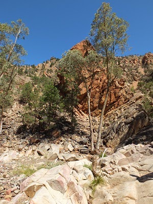
Many different rocks in Brachina Gorge
The gorge is famous for it's geology with millions of years worth of rock layers which have been uplifted to about a 45 degree angle then eroded.


Tuesday, 7 October 2014

Exploring the Flinders

7th October 2014

A pleasant day as the wind had dropped, clear blue skies and moderate temperatures. Perfect for bush walking.

We climbed to the Arkaloo rock art site.  The art is a dreamtime story describing the creation of the Flinders ranges, but unfortunately no interpretation was available to describe the meaning or age of the art.  At least it is well protected from vandals with an iron cage around the rock overhang.
Arkoola Rock Art

The views from the hill were lovely, the rocks are very red and everything is so dry.  On the plains where the water sometimes flows after rain, there are magnificent river red gums following the creek lines.  Further up the slope there is a forest of cypress pines with some eucalypt mallees.

Slab and pug workers accommodation 1853
After lunch we wandered around the old Wilpena station which was in operation from the mid 1850's until the mid 1940's.  They ran sheep but the country is so dry it was hard work.  The oldest buildings are slab and pug construction, which is to say they are built on a frame of cypress logs, the walls infilled with cypress logs and the gaps filled with a mixture of gravel, mud and lime. Sometimes this was refined with whitewash inside and out.  The roof was thatched with native grasses [later corrugated iron was added over the top of the thatch] and the floor was usually compacted earth. Must have been awful to live in. The temperatures around here can go 8 degrees below freezing in the winter and 55 degrees in the summer.

Blacksmiths shop
Most of the old pens and fences are gone, but there is a little triangle left where the rails were nailed directly to a tree by way of a corner post.  The tree has continued to expand and the ends of the rails are now engulfed inside the trunk.


Emus in the Flinders


There were large flocks of emus around, including a Dad with chicks.  The male emu incubates the eggs and looks after the chicks until they are about 18 months old.


Monday, 6 October 2014

Port Augusta to Wilpena Pound, Flinders Ranges

6th October 2014

After a very hot night in Port Augusta we set off for the Flinders Ranges, stopping off in Quorn on the way.  Quorn is in a picturesque valley and was founded for farming.  Due to the aridity of the area farming was not successful and now there are just a few sheep run on the hills.

In 1877 a narrow gauge railway line from Port Augusta was commenced with the ambitious goal of going all the way to Darwin.  This of course was the Ghan.  The route went through Quorn and eventually got as far as Alice Springs in 1929.  A line was started at the Darwin end but didn't ever reach very far south.

After the Japanese bombing of Darwin in 1942, thousands of troops were shipped to Alice on the Ghan line to set up defences across the Northern Territory.  Quorn became an important stop where they were given a cooked dinner by volunteers of the Country Womens Association.  A kitchen and mess hall was built for the purpose [still there].

Pichi Richi railway at Woolshed Flats
In the 1950's the southern end of the line was re-routed further to the west using standard gauge tracks; the passengers and freight had to change from one train to the other at the intersection of gauges. Quorn then became a backwater. Now railway enthusiasts run the old engines and carriages on a tourist railway known as the Pichi Richi  heritage railway.  They do a great job.  We went on a 2.5 hour round trip to Woolshed Flat from Quorn. Unfortunately they couldn't use the steam engine today as it was hot and windy so there is a total fire ban.  We were pulled by an old diesel engine instead

Eventually, by 1980 the entire original line of the Ghan through to Alice was rerouted and changed to standard gauge.  In 2004 the remaining track from Alice to Darwin was eventually completed.

Sunday, 5 October 2014

Penong to Port Augusta

5th October 2014

Another big effort by John on the driving today.  Great deal of confusion about the time - we went forward 1.5 hours from WA but hadn't realised that SA has also moved to daylight saving.  So we thought we did quite well leaving by 8:00am but it was in fact 9:00!

Ford Model A 1928
On the way we met a couple at a rest stop with their vintage car and custom made little van, which is just big enough to take a double mattress and nothing more!  The bloke made it himself.  The car is a Ford model A 1928, meticulously restored.  The owners had been to a rally in Bussleton,  We have seen many other vintage cars that took part in this rally.  

Anyway, we made good time through all the little wheatbelt towns and arrived in Port Augusta in time to go to Coles and stock up then arrive into the caravan park by 5:00. Normally this would be a problem, but it still isn't dark at 7:00. Huge variation in temperature today, we had lunch with a temp about 18 degrees and by the time we got here it was 33 with no signs of cooling off.  We have just given up on natural cooling and put the AC on for the first time on this trip.

Saturday, 4 October 2014

Eucla to Penong

4th October 2014

Another long drive, crossing the border into SA then a big push east.

Flat and treeless all around the lookout
Bunda Cliffs lookout
We stopped off at a couple of lookouts over the Bunda cliffs.  It was much cooler today and fine drizzle just about the entire journey.

Friday, 3 October 2014

Moodini Bluff to Eucla

3rd October 2014

Much shorter drive today and guess what, it rained.  Rainfall on the plain is about 250mm per annum so this was unusual.

Rain clouds on the Nullarbor [Mundrabilla roadhouse]
As we left the rest area very early we were the first ones into the caravan park at Eucla and could pick the prime position on the top of the scarp with views down to the southern ocean 5 kms away.

View over the cliff to the sea at Eucla
For the majority of the Nullarbor plain, the limestone plateau ends abruptly at the sea with sheer cliffs about 80 metres high.  Between Caiguna and Eucla however, sand has blown in over thousands of years and created a plain between the cliffs and the sea.  This is the Roe Plain and varies in width from 1 to 40 km.  The Eyre Highway travels on the Nullarbor plain for most of it's length, but drops onto the Roe plain between Madura and Eucla.  The little settlement of  Eucla sits on top of the cliffs so we were able to place our caravan near the edge of the scarp with a great view catching the cooling sea breezes.  We arrived here about 10.00am but it was already 28 degrees.

Eucla wasn't always in this position.  When it was an important and remote link in the telegraph line between Adelaide and Perth, the telegraph station and the settlement were built on the sand plain about 500 metres back from the sea shore.  This was in 1877.
Jetty at Eucla
A jetty was constructed with a tram line so ships could supply the town and wool bales could be shipped out.  A plague of rabbits arrived in the area in the 1890's eating all of the sparse vegetation.  This meant the dunes became unstable and mobile and gradually blew over the settlement, entirely covering some buildings and leaving others with just the tops of the walls exposed.

Old telegraph station at Eucla buried in sand


As we didn't want to unhitch the van we walked down the scarp and along the dirt road to the old settlement and then through the dunes to the sea.  It was hot and dusty and the flies were terrible.  Glad we had the 'nerd nets'to wear.

Thursday, 2 October 2014

Norseman to Moodini Bluff rest area

2nd October 2014

Free camping tonight and even though we are 26 kms from the Madura roadhouse we are getting internet reception.

Very long drive today, but it means about a 3rd of the crossing is done.  Tomorrow we will only drive to Eucla on the WA border so we have time to explore the old telegraph station.

Caiguna blowhole
The journey was tedious.  We stopped at the Caiguna blowhole to make lunch.  The Nullarbor plain is a limestone plateau honeycombed with caves beneath.  Where the cave system has sink holes to the surface the cave 'breathes'. Depending on the atmospheric pressure the air is sucked in or blown out through the sinkhole. Today the cave was blowing out. The air temperature was 28 degrees but the air blowing out was about 10 degrees cooler and surprisingly noisy.


The entire Nullarbor plain is reputed to have a population of 86, now we know where 8 of them live.  Cocklebiddy is a roadhouse smack in the middle of the WA side.


Wednesday, 1 October 2014

Esperance to Norseman

1st October 2014

Left Esperance for the homeward leg today.  Norseman is a good place to fill the water tanks, fuel the car, check the tyres etc before leaving on the long trek east across the Nullarbor.

Salmon Gum blossom
There are lots of little ghost towns on the route to Norseman, all of them were founded on gold prospecting. They came and went very quickly and now the only sign left is a few tracks through the bush.
Norseman statue
Norseman was reputedly founded when a prospectors horse, called Hardy Norseman, scratched the ground and found a huge gold nugget just under the surface.  There is a statue of Norseman on the corner of Ramsay and Roberts streets [significant names].
Camel art in Norseman
The town has wide streets, they had to be big enough to turn a camel train, common through here until the late 1920's.  Now the town really just survives because it is a convenient stop for travelers arriving or leaving the state from the east and also a handy north south stop off.  The caravan park is very busy tonight but fortunately John phoned ahead and booked a drive through site which means it wasn't necessary to unhitch. So a really quick start in the morning.

Tuesday, 30 September 2014

Around Esperance

30th September 2014

Today was preparation for departing Esperance tomorrow to start the big trek east.  Feels like the holiday is nearly over.

Esperance beach
Esperance is a really lovely little town with a great walk/cycle track along the expansive coastline.  We walked the track this morning even though it was a bit drizzly, it soon cleared up though.
There are a string of lakes behind the sand dunes, parallel to the sea shore.  A board walk has been constructed around some of these lakes with a couple of bird hides installed.  We walked this in the afternoon but there weren't many birds around, just ducks.

Model of skylab which crashed near Esperance
Outside the Esperance Museum is a model of the first American skylab, launched in 1973.  In 1979 the apparatus fell to earth at Balladonia which is an area on the Nullarbor about 140km from here.

Monday, 29 September 2014

Cape Le Grande NP - then Esperance

25th to 29th September

We arrived in Esperance today after 3 nights in the Cape Le Grande National Park. The beaches within the park are reputed to have the whitest sand in the world and they are stunningly beautiful.

Lucky Bay 
The blue of the ocean is also unbelievable.
Lucky Bay from the campsite
The most beautiful of all is Lucky Bay which is where we were lucky enough to camp. Wonderful views, great company, ablutions and water all for $13.20 per night!

Lucky Bay
The bay was named in 1802 by Matthew Flinders when he was circumnavigating Australia.  He experienced bad weather, found the bay which is sheltered from the elements and he considered this lucky.

Sand as white as snow
The cape and many of the features in the vicinity were named by the Frenchman DÉntrecasteaux who sailed past on a voyage of discovery in the late 18th century.  His ships were the Recherche and the Esperance, hence the name of the modern city.

Kangaroos visit the beach at dusk and feed on washed up seagrass
The sand is formed from very small grains so they stick together and crust on the surface of the beach so walking over the sand crunches like snow!

Ornate Dragon, well camouflaged on the granite

This area is known for it's sudden storms and strong winds and we got a taste of this on our second afternoon.  The weather changed from a beautiful still morning with temperatures in the mid 20's to wind gusts of 50km/h and a drop to 13 degrees.  Some rain too.

Frenchmans Peak
Halfway up Frenchmans Peak
Under the 'Peak'
We had a great time walking the headlands and the beaches and this morning we climbed Frenchman's Peak, which is mostly a scramble up the granite walls. We were on the top by 8:15am enjoying the outstanding views and exploring the arch.  We had the entire mountain to ourselves at that time of the morning!